Geography
The Canadian Shield is a region that has sedimentary bedrock below the land. This area has a great region of Precambrian rock and, It is rugged and hilley. The main region is in Ontario, Quebec and the Maritimes, but it also includes Northern Manitoba and further North Ice sheets during the last ice aged created the lakes and deposited the rocks throughout thee region. The coordinates for the Canadian Shield region are 120 degrees West to 60 degrees West. It also ranges from the 42 degress North to 70 degrees North at Hudson Bay.
The Canadian Shield Forest Lands were created from the bedrock forming the heart of the North American continent. In fact, the Canadian Shield is the largest part of the craton's bedrock. Also it is a part of an old continent called Arctica, (formed 2.5 million years ago during the Neoarchean era)
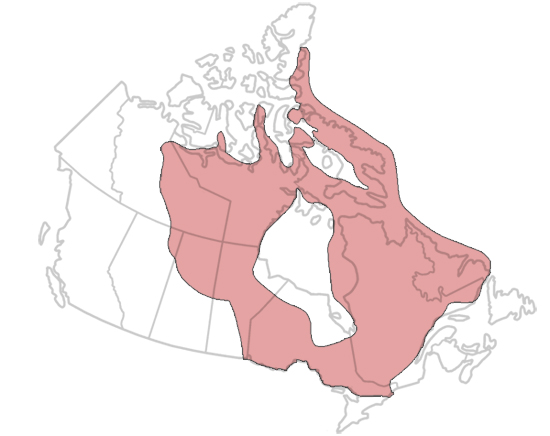
This is a map of The Canadian Shield Forest Lands
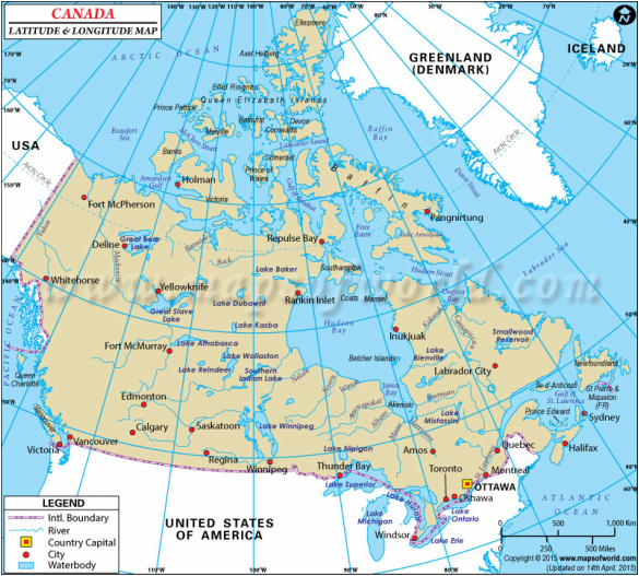
This is a map of the latitude and longititude.
Climate
The temperature of this region are very different because the area is so big. Tempertures are cold in the winter (-15 degrees) and there is lots of rain each month (75 mm or more).
Muskoka temperatures range from -16to +25 degrees. Monthly precipitation ranges from 63 to 110 mm of rain each month.
Ottawa temperatures range from -15 to +25 degrees. Monthly precipitation ranges from 9 to 90 mm of rain each month.
Newfoundland temperatures range from -24to +15 degrees. Monthly precipitation ranges from 30 to 74 mm of rain each month.

This is Muskoka climate graph

This is Ottawa, Ontario's climate graph
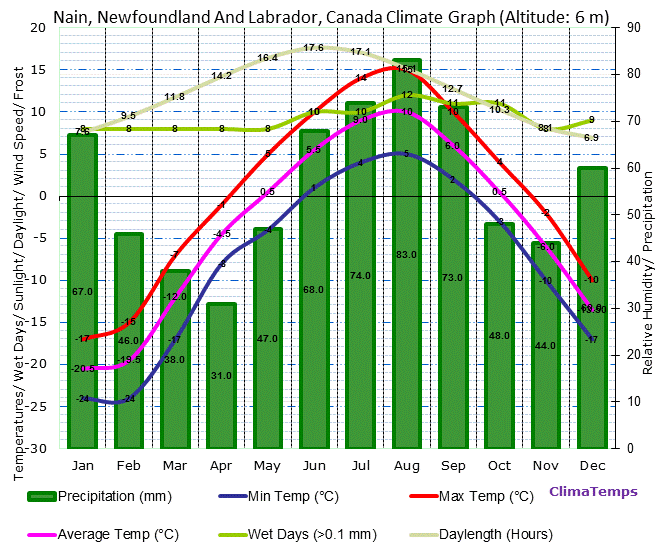
This is Labrador's climate graph
Soil Profile
The Canadian Shield's soil profile is actually just mostly rock, and the exposed bedrock from the precambrian era which existed 500 million years ago. It is just very thin soil on top of bedrock.
Causal Climate Factors and Impact of Climate Change.
Climate change is having an impact on the Canadian Shield because as the North is warming, it is causing an problem for animals like the Caribou to be able to migrate to areas in the spring where they can eat food and raise their babies. Also the ice caps are melting faster and this is causing the polar bears to have a diffucult time in being able to hunt for their food.
Flora and Fauna of the Region
The Flora of this region has a variety of things. This includes black spruce, paper birch, trembling aspen, balsam fir, etc. Many of the rocks and places of the area are covered with lichen as well.
The Fauna of this region is very diverse, and include multiple specific species of animals. Here there are moose, black bears, woodland caribou ,snowshoe hare, lynx , and grey wolves . Birds of this area are the great horned owl, northern hawk owl, Canada goose, pileated woodpecker, and the wood duck.
All of the flora and fauna have adapted to the Canadian Shield by their own creative ways, like the Canadian geese adapts by going places in flocks which will drive predators away, and bears hibernate, and hunt for prey and berries after winter is over.
Human Geography
Over the years people have settled in these many of these areas. There use to be lots of Algonquin First Nations that would use birchbark canoes and travel up and down the rivers and trade furs.
Some of the major cities now in this region now include Muskoka, the capital of Canada Ottawa, and all the way to Newfoundland.
Economy
Past In the past some of the economy was fur trade, fishing, and in fact logging and forestry were a big part, mostly pulp and paper. Resource extraction has also been a big part of the regions past economy, using mines and smelters. For example, in 1902 the International Nickel Company (Inco) was created to mine the worlds best sections of nickel, copper and silver. However, this regions reliability on resource extraction has led to major economic and environmental issues. Another thing was the people made an effort for tourism, retirement, for the economy.
Present
Some of the present industries in the Canadian Shield are ones that were in the past. For example, forestry and pulp and paper are still an industry used in this region today, also there is resource extraction as well. But the mining and smelting have produced tailings (waste left after mining and smelting) has producing environmental concerns and issues.
Environmental Concern
One major thing that is affecting this region is acid rain. Acid rain is rainfall made by atmospheric pollution of sulfur dioxide and nitrogen oxide that are released from the mining plants. It can destroy the environment, aquatic life, forests, crops and buildings, and is a problem to humans because it can cause threats to health. Acid rain can also cause air pollution as well, but is caused by pollution from cars. In fact, Canada and the United States created the "Air Quality Accord" that seems to control the air pollution across international borders and has helped control some acid rain. I think they should keep doing what there doing to help with acid rain because it could help a lot more just like it already has (Acid rain attacks a places granite bedrock and soils and The Canadian Shield is made up of granite bedrock which would spread easily). Electric cars would probably help as well by not polluting the air.
Comparison to another location
I am comparing this region to the Gallatin National Forest, right by this city called Bozeman in Montana. Both regions have a dense forest, and rocky hillsides.
This is the Canadian shield forest lands compared to........
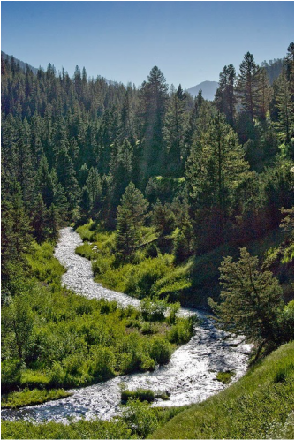
The Gallatin National Forest in Montana.
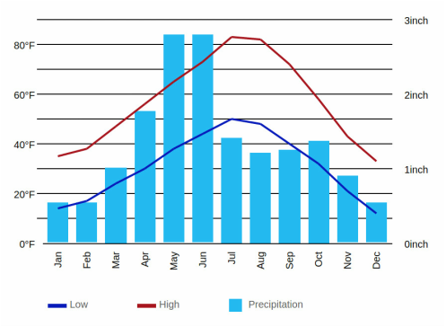
Here is a climate graph for the nearby city called Bozeman that shows the precipitation and temperature
The economic activities in Bozeman are agriculture, ranching and cereal grain farming, oil, gas, coal, hard rock mining, lumber, and tourism.
References
http://www.thecanadianencyclopedia.ca/en/article/shield/
https://www.google.ca/search?q=quebec+climate+graph&espv=2&biw=1360&bih=652&source=lnms&tbm=isch&sa=X&ved=0ahUKEwjA26GR_JPNAhUIyGMKHfUnAcAQ_AUIBigB#imgrc=iMMjbfHitiXtaM%3A
https://www.google.ca/search?q=ontario+climate+graph&espv=2&biw=1360&bih=652&source=lnms&tbm=isch&sa=X&ved=0ahUKEwjhla2X_JPNAhVY82MKHZ_IC4cQ_AUIBigB#imgrc=VcMzpiZly7mKuM%3A
https://www.google.ca/search?q=labrador+climate+graph&espv=2&biw=1360&bih=652&source=lnms&tbm=isch&sa=X&ved=0ahUKEwi0rOKb_JPNAhVaVWMKHdmkBNsQ_AUIBigB#imgrc=sIPsfW-5q9WZkM%3A
https://en.wikipedia.org/wiki/Canadian_Shield
https://en.wikipedia.org/wiki/Central_Canadian_Shield_forests
http://www.canadianshieldfoundation.ca/?page_id=39
http://partner.galileo.org/schools/gibson/4-5_fp/geography/issue/canadianshield_i/canadianshieldi_2.htm
http://www.mapsofworld.com/lat_long/maps/canada-lat-long.jpg
http://www.muskoka.climatemps.com/muskoka-climate-graph.gif
https://www.google.ca/search?q=Gallatin+National+Forest&source=lnms&tbm=isch&sa=X&ved=0ahUKEwiRsa-w2Z3NAhWMRI8KHXphDIwQ_AUICSgC&biw=1920&bih=911#tbm=isch&q=canadian+shield+forest+lands&imgrc=KQ4MFN6uFZ7vKM%3A
https://www.google.ca/search?q=climate+graph+for+jardine+montana&sa=X&espv=2&biw=1920&bih=911&tbm=isch&imgil=WrNQEGUTr-nBWM%253A%253B7p9_0bIdQv5grM%253Bhttp%25253A%25252F%25252Fclimate-data.org%25252Flocation%25252F125664%25252F&source=iu&pf=m&fir=WrNQEGUTr-nBWM%253A%252C7p9_0bIdQv5grM%252C_&usg=__6nnoxVRRLw857xzL90oJiQhFRa8%3D&ved=0ahUKEwigoMrU253NAhWJpo8KHdA7AWIQyjcIOA&ei=3dRaV-C9JYnNvgTQ94SQBg#imgrc=WrNQEGUTr-nBWM%3A
https://en.wikipedia.org/wiki/Montana
