Geography
The Appalachia region of Canada is located from the lower eastern part of Quebec, all the way into New Brunswick, Nova Scotia, Prince Edward Island and Newfoundland.
The coordinates for the St. Lawrenece Lowlands 80 degrees West to 50 degrees West. It also ranges from the 45 degrees North to 60 degrees North.
The Appalachia was formed by belts of folded and thrust faulted ocean sedimentary rocks, volcanic rocks and slivers of the sea floor. Evidence that these rocks were deformed during plate collisions.
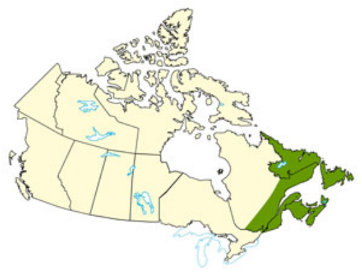
This is a map of the Appalachia

This is its latitude and longitude
Climate
The climate of the Appalachian region is temperate and humid and can be effected by the ocean currents since it is mainly along the ocean. The annual temperature is about 3.5°C, The summer temperature is 14.5°C, and the winter temperature is -8°C. With an annual precipitation of 900-1300 mm.
Newfoundand temperatures range from -24 to +15 degrees. Monthly precipitation ranges from 31 to 83 mm of rain each month.
Halifax temperatures range from -7 to +23 degrees. Monthly precipitation ranges from 94 to 140 mm of rain each month.
St. Johns New Brunswick temperatures range from -13 to +22 degrees. Monthly precipitation ranges from 100 to 170 mm of rain each month.

Newfoundland's climate graph

Nova Scotia's climate graph

New Brunswick's climate graph
The soil profile and land of the Appalachia ranges from cliffs of sedimentary rock to mud flats and salt marshes. Climate change is having an impact on the Appalachia because with the rising temperatures it is causing dried-up streams and more forest fires in the area. This could be a big problem because it could eventually kill the area and its forests. This would have an impact on the forest economy and tourism.
Flora and Fauna of the Region
The Flora of this region is very vast and interesting. This region has many different trees such as red spruce, sugar maple, beech, poplar, walnut etc. There are also dog wood, locust, redbud and other different trees and plants. The Fauna of this region mainly consists of bigger animals. There are elk, bison, moose, black bears, white-tailed deer, raccoon, bobcat, coyote, otter, muskrat, wild boar, fox, raccoon, beaver and many small animals as well. There are also Gulls, black guillemots, razor-bills, double-crested cormorants and many different types of birds. All of the flora and fauna have adapted to the Appalachia by their own specific ways.
Human Geography
The population density of the Appalachia region is 123.5 people per square mile of land area, and the population in this area is about 25,243,456. Some of the major cities in this region are New Brunswick, Prince Edward Island, Nova Scotia, the island of Newfoundland, etc. Humans use the physical features of this land by Fishing and making a profit and for food, mining for resources and as well as forestry and places for more house to be built for people to come and live in.
Economy
Past In the past the economy of this region was Canada's easternmost economic region. Major resources there are forests, fish and farmland, there is also mineral sections of zinc, coal, lead, and there is oil reserves as well. Agriculture there started with Acadian settlers in the 17th century, which included farming, (potato) in the red soils of New Brunswick and PEI. Forests were also another major industry there, which added to the economy.
Present
Some of the present industries in the Appalachia are the same but others are different. Today, the drop of cod and ground fish markets brutalized the fishing industry and the communities built over that for hundreds of years. This happened by over fishing, trawlers, and overestimates of markets. However, the agriculture industry is still thriving today, for example the McCain Food Limited. Created in 1957, this company processed fries and its annual sales were $152,67, and in 1997 sales were $4.15 billion. The oil fields still strive as well, just like the Hibernia oil field which has an approximately 615 million barrels of oil.
Environmental Concern
Once of the environmental concerns with this area is coal mining. Coal is taken from the top of the mountains and extracted and used to generate energy/electricity. This is causing a the vegetation to be killed and the biodiversity of the forest to be altered.. Also, the extract rocks are then removed and dumped in nearby valleys.
Comparison to other locations
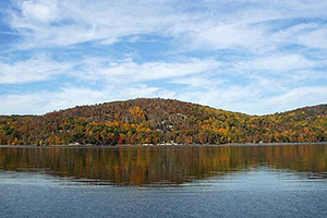
I am comparing this region to New Jersey, and the forests around it.
Flora and Fauna of the Region
The Flora of this region is very vast and interesting. This region has many different trees such as red spruce, sugar maple, beech, poplar, walnut etc. There are also dog wood, locust, redbud and other different trees and plants. The Fauna of this region mainly consists of bigger animals. There are elk, bison, moose, black bears, white-tailed deer, raccoon, bobcat, coyote, otter, muskrat, wild boar, fox, raccoon, beaver and many small animals as well. There are also Gulls, black guillemots, razor-bills, double-crested cormorants and many different types of birds. All of the flora and fauna have adapted to the Appalachia by their own specific ways.
Human Geography
The population density of the Appalachia region is 123.5 people per square mile of land area, and the population in this area is about 25,243,456. Some of the major cities in this region are New Brunswick, Prince Edward Island, Nova Scotia, the island of Newfoundland, etc. Humans use the physical features of this land by Fishing and making a profit and for food, mining for resources and as well as forestry and places for more house to be built for people to come and live in.
Economy
Past In the past the economy of this region was Canada's easternmost economic region. Major resources there are forests, fish and farmland, there is also mineral sections of zinc, coal, lead, and there is oil reserves as well. Agriculture there started with Acadian settlers in the 17th century, which included farming, (potato) in the red soils of New Brunswick and PEI. Forests were also another major industry there, which added to the economy.
Present
Some of the present industries in the Appalachia are the same but others are different. Today, the drop of cod and ground fish markets brutalized the fishing industry and the communities built over that for hundreds of years. This happened by over fishing, trawlers, and overestimates of markets. However, the agriculture industry is still thriving today, for example the McCain Food Limited. Created in 1957, this company processed fries and its annual sales were $152,67, and in 1997 sales were $4.15 billion. The oil fields still strive as well, just like the Hibernia oil field which has an approximately 615 million barrels of oil.
Environmental Concern
Once of the environmental concerns with this area is coal mining. Coal is taken from the top of the mountains and extracted and used to generate energy/electricity. This is causing a the vegetation to be killed and the biodiversity of the forest to be altered.. Also, the extract rocks are then removed and dumped in nearby valleys.
Comparison to other locations
I am comparing this region to New Jersey, and the forests around it.
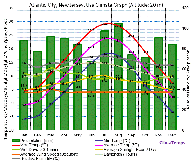
This is the climate graph for Atlantic city in New Jersey.
Both areas receive lots of rain and roughly the same temperature. (100mm rain per month, and -5 degrees to 30 degrees)
References
https://en.wikipedia.org/wiki/Appalachian_Mountains
https://www.google.ca/webhp?sourceid=chrome-instant&ion=1&espv=2&es_th=1&ie=UTF-8#q=how%20was%20thge%20appalachia%20formed
https://en.wikipedia.org/wiki/Appalachia
http://www.pc.gc.ca/eng/docs/v-g/nation/sec5.aspx
https://www.google.ca/search?q=Newfoundland+climate+graph&biw=1920&bih=955&tbm=isch&imgil=sIPsfW-5q9WZkM%253A%253B_SPzMrVZcTDLeM%253Bhttp%25253A%25252F%25252Fwww.nain.climatemps.com%25252F&source=iu&pf=m&fir=sIPsfW-5q9WZkM%253A%252C_SPzMrVZcTDLeM%252C_&usg=__tBjA66xtjH-rdM-bLcvOfbBpqyk%3D&ved=0ahUKEwjaycfY05nNAhXHPI8KHXMUAc0QyjcIJg&ei=o7NYV5rsH8f5vATzqIToDA#imgrc=sIPsfW-5q9WZkM%3A
https://www.google.ca/search?q=Nova+Scotia+climate+graph&biw=1920&bih=955&tbm=isch&imgil=Hz_rWY20ThA2wM%253A%253BVqO6TH06i9UbAM%253Bhttp%25253A%25252F%25252Fwww.halifax.climatemps.com%25252F&source=iu&pf=m&fir=Hz_rWY20ThA2wM%253A%252CVqO6TH06i9UbAM%252C_&usg=__kymqFqQspkW5s6Z9p5xB8FRG36s%3D&ved=0ahUKEwjw4Ofa05nNAhUQTI8KHaAMCLYQyjcIJg&ei=qLNYV_DsDpCYvQSgmaCwCw#imgrc=Hz_rWY20ThA2wM%3A
https://www.google.ca/search?q=New+Brunswick+climate+graph&biw=1920&bih=955&source=lnms&tbm=isch&sa=X&ved=0ahUKEwitsbXd05nNAhXEvI8KHTasCUcQ_AUIBigB#imgrc=_DupzKcQYdOSNM%3A
http://www.britannica.com/place/Appalachian-Mountains/Plant-and-animal-life
http://www.prb.org/pdf12/appalachia-census-chartbook-2011.pdf
https://www.meteoblue.com/en/weather/forecast/modelclimate/appalachian-mountains_united-states-of-america_5178401
http://ecozones.ca/english/region/117.html
http://www.huffingtonpost.com/2012/06/06/nature-conservancy-study-global-warming_n_1574671.html
http://www.mapsofworld.com/lat_long/maps/canada-lat-long.jpg
https://en.wikipedia.org/wiki/Mountaintop_removal_mining
https://www.google.ca/search?q=New+Jersey+Highlands&tbm=isch&imgil=r8__sBNNlWDXUM%253A%253B88mbgtGd8U1JmM%253Bhttp%25253A%25252F%25252Fwww.njconservation.org%25252Fheartofhighlands.htm&source=iu&pf=m&fir=r8__sBNNlWDXUM%253A%252C88mbgtGd8U1JmM%252C_&usg=__nJOdB5wmWpBVafusTDeA3XBGkhk%3D&biw=1920&bih=911&ved=0ahUKEwigva_C5J3NAhXJRI8KHSXoD4QQyjcINQ&ei=J95aV-CNFcmJvQSl0L-gCA#imgdii=r8__sBNNlWDXUM%3A%3Br8__sBNNlWDXUM%3A%3BIlyxRg54qtk2uM%3A&imgrc=r8__sBNNlWDXUM%3A
https://www.google.ca/search?q=new+jersey+highlands+climate+graph&espv=2&biw=1920&bih=911&tbm=isch&imgil=Y6X9vfG4OwZVpM%253A%253B2oRLpCQoqpAemM%253Bhttp%25253A%25252F%25252Fwww.atlantic-city.climatemps.com%25252F&source=iu&pf=m&fir=Y6X9vfG4OwZVpM%253A%252C2oRLpCQoqpAemM%252C_&usg=__VQpyZvnyMiIlqycEDiQ98tXuVN0%3D&ved=0ahUKEwjMu8Tl5J3NAhUEtI8KHdFHBB0QyjcIKQ&ei=cd5aV4y_BYTovgTRj5HoAQ#imgrc=Y6X9vfG4OwZVpM%3A
