Geography
The Interior Plains region of Canada is located in Alberta, Saskatchewan and Manitoba and part of Ontario and goes from the Canadian Border all the way north into the North West Territories. The coordinates for the interior plains are from Alberta (115 Degrees West) towards the Ontario Border (95 degrees West). It also ranges from the Canadian Border at the (49th degrees North) all the way North to the Yukon (70th degree North).
The Interior plains (land form formed when cratons collided and went together 1.9 billion years ago) were originally covered by shallow inland seas 500 million years ago. Sediments from the Rocky Mountains then were deposited as well as sediments from rivers flowing into the area over millions of years. Over lots of time, the sediments were pressed together by the weight of the layers sedimentary rock which over lots of time eventually created the Interior plains.
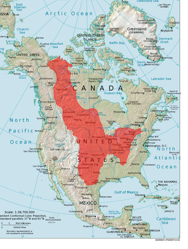
This is a map of the Interior Plains
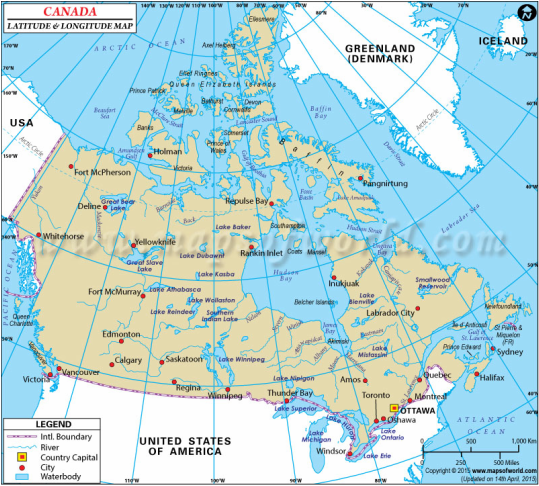
This is a map of the latitude and longitude
Climate
In the Interior plains the temperatures can vary. In the winter it can go as low as -25 degrees, and in the summers 25 degrees or higher. The precipitation of this region is about 300mm to 500mm a year.
Winnipeg's temperatures range from -20 to +25 degrees. Monthly precipitation ranges from 14 to 85 mm of rain each month.
Calgary's temperatures range from -15 to +22 degrees. Monthly precipitation ranges from 10 to 80 mm of rain each month.
Saskatoon's temperatures range from -22 to +12 degrees. Monthly precipitation ranges from 12 to 64 mm of rain each month.

Winnipeg Manitoba climate graph

Calgary Alberta climate graph

Saskatoon Saskatchewan climate graph

Soil Profile.
The Interior Plains have fertile, rich, soft soil that is good for growing plants. The soil can be brown and black.
Causal Climate Factors and Impact of Climate Change.
Climate change is having an impact on the prairies. 40% of the droughts have occured in Western Canada over the last century. The prairies are becoming dry and receive very little rain each year, and with climate change and global warming, the prairies are becoming hotter and drier. Droughts are now affecting the crops and cattle farming. There is also less snow cover during some winters which is reducing the amount of precipitation the soil receives.
Flora and Fauna of the Region
The Flora of this region is more mixed grassland known as the prairies. There are June grass, and Porcupine grass, Bluestem grasses, and sagebrush. Some of these can grow to 8 feet tall such as the Porcupine, which has a bloom at the end. There is also oats, barley, and wheat which farmers grow and trees like black spruce, balsam fir, tamarack, water birch, Bebb willow, peachleaf willow etc.
The Fauna of this region consists of badgers, coyotes, badgers, wolves, deer, antelope, elk, brown bears, muskrats, cows, bison, western rattlesnake, spruce grouse, red-tailed hawk etc.
All of the flora and fauna have adapted to the prairie regions and lower amounts of precipitation in order to grow and live. They can also survive in cold winters and warm summers. A lot of the animals fur colours are similar to the grasslands and some of the animals are able to burrow holes into the ground so they can hide from predators.
Human Geography
Settlement Patterns and Major Cities
Over the years people have settled in the areas where there are rich soils for farming and near large lakes and rivers
Some of the major cities in the Interior Plains are Edmonton, Calgary, Winnipeg, and Saskatoon. People use the land for multiple of things. One is drilling/mining for oil, coal, gold, uranium and other minerals. People also farm wheat, oats, barley on the rich soil land etc.
Economy
Past In the past the economy of the region was similar to what they still do now. This region turned into a leading world exporter after most of the grasslands in the southern areas were ploughed under. Agriculture is another thing which happens to dominate the economy, (more than 80% of Canada's farmland is there). Another thing in the role of the economy back then was the petroleum (a dark viscous material found in the upper strata of the Earth) industry, and mining for oil etc.
Present Some of the present industries in the Interior Plains are oil and gas. But more importantly the also make their economy from agriculture (wheat, oats, barley), Forestry, and pulp, paper and saw mills are also another major industry in this region. Crops also include sugar beets, corn, potatoes etc. Livestock is also another thing farmers do, they raise pigs, cattle, horses. Mining is a key industry there as well, they mine products like coal, zinc, gold, oil, natural gas etc.
Environmental Concern
Climate change is impacting the Canadian Prairies. The prairies are already dry and receive very little rain each year, and with climate change and global warming, the prairies are becoming hotter and drier. 40% of the droughts have occured in Western Canada. Droughts are now affecting the crops and cattle farming. There is also less snow cover during some winters which is reducing the amount of precipitation the soil receives.
Comparison to other Locations.
I am comparing this to North Dakota, in the United States. In the United States it is known as the Great Plains whereas in Canada it it the Interior Plains. This region has a lot of grasslands like Saskachewan and Manitoba. People have adapted to this region by cattle ranching and farming wheat. In addition, this area has many fossil fuels for natural gas and oil.
The weather between Winnipeg and North Dakota are very similar. Temperatures range from -20 to +25 degrees. Monthly precipitation ranges from 14 to 70 mm of rain each month.
References
https://www.google.ca/search?q=interior+plains+map&espv=2&biw=1920&bih=911&source=lnms&tbm=isch&sa=X&ved=0ahUKEwin3Z3tlJLNAhVK8GMKHVUpC2gQ_AUIBigB#imgrc=ca22iyGn6TcOtM%3A
http://www.canadiangeographic.ca/atlas/themes.aspx?id=canadianlandforms&sub=canadianlandforms_land_plains&lang=En
https://en.wikipedia.org/wiki/Interior_Plains
https://www.google.ca/search?q=calgary+climate+graph&biw=950&bih=869&tbm=isch&imgil=U
o9ghQsukWapQM%253A%253BYYCjKDX5Avv0qM%253Bhttp%25253A%25252F%25252Fwww.
calgary.climatemps.com%25252F&source=iu&pf=m&fir=Uo9ghQsukWapQM%253A%252CYYCjK
DX5Avv0qM%252C_&usg=__AEorTRdvhhOACZmREqeC2WLWjbI%3D&ved=0ahUKEwj9kO3amZ
LNAhWKuo8KHTuGBIcQyjcILg&ei=UMtUV_2oN4r1vgS7jJK4CA#imgrc=Uo9ghQsukWapQM%3A
https://www.google.ca/search?q=interior+plains+map&biw=1360&bih=606&source=lnms&tbm=isch&sa=X&ved=0ahUKEwiE9qbx-pPNAhVY0GMKHQy4CNcQ_AUIBigB#imgrc=ca22iyGn6TcOtM%3A
https://www.google.ca/search?q=winnipeg+climate+graph&biw=950&bih=913&source=lnms&tbm=isch&sa=X&sqi=2&pjf=1&ved=0ahUKEwiirdndmZLNAhWJpo8KHcvcAsIQ_AUIBigB#imgrc=KMw9OzB2ZSVBpM%3A
http://interiorplains.weebly.com/climate.html
https://en.wikibooks.org/wiki/Canadian_History/The_Wildlife_of_the_Lands
http://www.thecanadianencyclopedia.ca/en/article/geological-regions/#h3_jump_2
https://en.wikipedia.org/wiki/Drought_in_Canada
http://www.soils4teachers.org/lessons-and-activities/teachers-guide/prairie
http://hrsbstaff.ednet.ns.ca/jmmoore/pages/SS%20interior_plains.htm
https://en.wikipedia.org/wiki/North_Dakota
http://www.mapsofworld.com/lat_long/maps/canada-lat-long.jpg
