Geography
The St. Lawrence Lownlands is the plain area along the St. Laurence River all the way from Quebec City, Ottawa and down to Toronto Area.
The coordinates for the St. Lawrenece Lowlands 90 degrees West to 60 degrees West. It also ranges from the 42 degrees North to 50 degrees North.
The St. Lawrence lowlands were created by continental glaciation, followed by marine submergence, emergence and, river erosion and deposition.
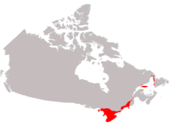
This is a map of the St. Lawrence Lowlands
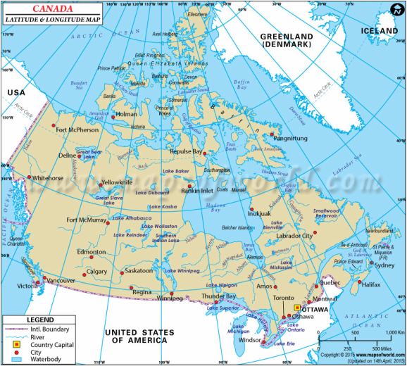
This is a map of the latitude and longitude
Climate
The temperature of this region varies as you can see in the climate graphs of the different cities above. In the winter There can be up to 80 cm of snow each winter and temperatures can go as low as minus 30 degrees Celsius. In the summer the temperatures can be high, with the humidity as well. The annual precipitation because of the humidity is only about 100cm of rain each year.
|Toronto temperatures range from -8 to +25 degrees. Monthly precipitation ranges from 50 to 70 mm of rain each month.
Ottawa temperatures range from -15 to +26 degrees. Monthly precipitation ranges from 50 to 90 mm of rain each month.
Montreal temperatures range from -15 to +265 degrees. Monthly precipitation ranges from 65 to 100 mm of rain each month.

This is Toronto's climate graph
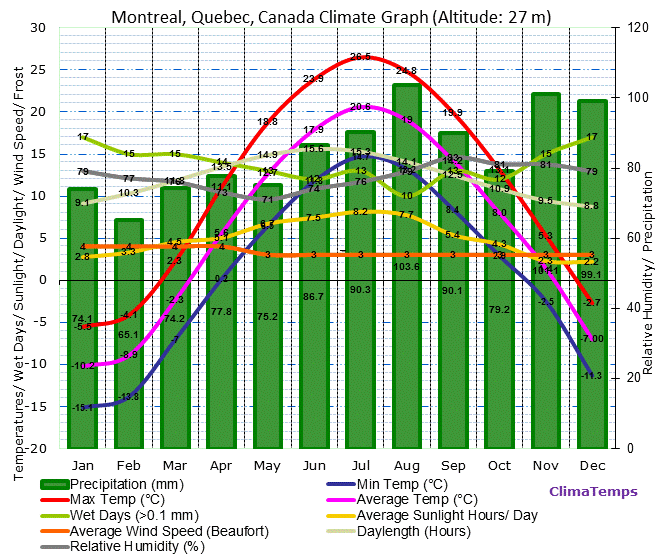
This is Montreal's climate graph
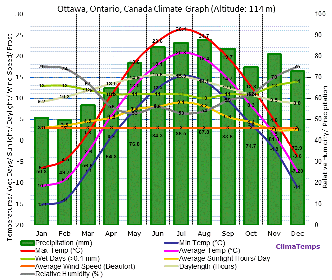
This is Ottawa's climate graph
Soil Profile
The the St. Lawrence Lowlands soil profiles are mainly clay deposited in the Champlain Sea. There is very fertile soil there and mild weather. However, the south and west regions of the lowland are glacial deposits rather than marine clay. The sand areas east of Montreal are leftovers of former rivers like the Ottawa and St. Lawrence. Some ridges of bouldery sand 1.5–4.5 m high and 30 m wide. This area has very pristine agricultural land, and Its clay can and has been used for brick and tile creation, and the sand and gravel deposits are used for road metal and construction items.
Causal Climate Factors and Impact of Climate Change.
The St. Lawrence region has many large cities that have been built in the area. As more people move into the area, there is also a lot of pollution, one of which is from waste being dumped into a waterway, or the lakes. Also there are more cars on the road which is adding to greenhouse gases and warming up the environment.
Flora and Fauna of the Region
The Flora of this region can grow very well in the fertile soil. The flora of this region includes walnut trees, American beech, basswood, white oak, red oak, black walnut and butternut, spruce, oak, maple, hemlock, and sometimes tobacco plants. Also this region has different types of forests like the Deciduous forest, Carolinian forest, mixed wood forest and mid-boreal and high-boreal forest. The Fauna of this region has green heron, loon's, cardinals, red squirrel white-tailed deer, grey squirrel, coyote, starling, house sparrow. Reptiles in this area are eastern spiny soft-shelled turtle, Blanding's turtle, box turtle, and fox snake. However there are also Moose, wolf, snowshoe hare, martin, spruce grouse. All of these flora and fauna adapt to their environment in there own special ways, could be hibernating, migration, and they all have there own source of food etc.
Human Geography
Settlement Patterns and Major Cities
Over the years people have settled in the areas because of the fertile soil, farming land, and being along the along the St. Lawrence River and Great Lakes which was/is a main way to transport goods and people.
Some of the major cities now in this region now include Ottawa the Capital, Toronto, Montreal and Quebec City.
Economy
Past In the past the economy of the region was very vast. This area has the St. Lawrence river and the Great lakes, which are both great waterways. In fact, fur trade and later on settlement around this area became real. There were towns built by the rivers and lakes so saw mills could have access to water power. Also there were water transportation routes that made it easier to go from community to community. Lumber was another big thing, as more of that happened the more land was cleared for agriculture. Iron and steel, clothing, breweries and oil refineries were also a big part of the economy, as well as the automotive business and the worlds first electronic switching.
Present
Some of the present industries in the St. Lawrence Lowlands are some of the past industries that kept going. Some of these are the automotive sector which has about 75,000 Canadian employees. This region is on the top of high finance and most of Canada's banks, trust companies, and insurance companies have head offices and buildings in Toronto or Montreal (in the St. Lawrence lowlands). The great lakes bring a big source or electrical power to the cities, which helps out a lot. Another present industry is agriculture as well.
Environmental Concern
An environmental concern of this region is how polluted the Great Lakes are, and the invasive species that got into the lake. In fact, every eight months a new species enters the Great Lakes and another leaves, which can be just as bad as pollution killing and messing up the ecosystem. There is also a lot of pollution, one of which is from waste being dumped into a waterway, or the lakes. Another is from the runoff from streets, lawns, a waterway sometimes carries toxins, chemicals, and silt into lakes, rivers, causing buildup of sediment and pollution. There is also air pollution that affects the lakes caused by smoke and chemicals being thrown into the air from smoke stacks and hospitals. The NWF is working to help and fund the plan to restore the Lakes that wants to protect and restore wildlife habitat, clean up toxic sediments, reduce polluted runoff, remove and prevent invasive species, and stop sewage from contaminating and polluting these great lakes. I think this is a good plan and they should keep doing it because these lakes are beautiful and worth saving and keeping.
Comparison to another location
I am comparing this to Buffalo, in the United States to Toronto. Both regions have warm humid summers and their winters are affected by the lake effect. Tourism is popular in both regions. The weather between Buffalo and Toronto are very similar. Temperatures range from -20 to +25 degrees. Monthly precipitation ranges from 14 to 70 mm of rain each month.

Here is a climate graph of Buffalo
Some economic activities in Buffalo are tourism because it is so close to Niagara falls which brings 10 million tourists a year, that way people can go shopping, stop by while they are there etc. Others are commercial shipping, resource extraction and trading, and they also have major banks as well.
Some economic activities in Buffalo are tourism because it is so close to Niagara falls which brings 10 million tourists a year, that way people can go shopping, stop by while they are there etc. Others are commercial shipping, resource extraction and trading, and they also have major banks as well.
References
https://www.google.ca/search?q=st+lawrence+lowlands+map&espv=2&biw=1440&bih=784&source=lnms&tbm=isch&sa=X&ved=0ahUKEwjJrc7DopbNAhUN5GMKHcgfCAQQ_AUIBigB#imgrc=9-YKmlP2TG7j5M%3A
https://www.google.ca/search?q=st+lawrence+lowlands+map&espv=2&biw=1440&bih=784&source=lnms&tbm=isch&sa=X&ved=0ahUKEwjJrc7DopbNAhUN5GMKHcgfCAQQ_AUIBigB#tbm=isch&q=lat+and+long+map+of+canada&imgrc=ubhYCwSfgmFmTM%3A
http://projects.cbe.ab.ca/ict/2learn/kdwajda/canada/studentwork/lowlands.htm
https://www.google.ca/search?q=ottawa+climate+graph&espv=2&biw=1920&bih=911&tbm=isch&imgil=VcMzpiZly7mKuM%253A%253BdmAkOeLWrdQcWM%253Bhttp%25253A%25252F%25252Fwww.ottawa.climatemps.com%25252F&source=iu&pf=m&fir=VcMzpiZly7mKuM%253A%252CdmAkOeLWrdQcWM%252C_&usg=__DkfVg62_kIM5hF2XpW-UDl_OYjs%3D&ved=0ahUKEwjL3NPQyZfNAhXGuY8KHXg0CX4QyjcINA&ei=p5xXV4vtBsbzvgT46KTwBw#imgrc=VcMzpiZly7mKuM%3A
https://www.google.ca/search?q=toronto+climate+graph&espv=2&biw=1920&bih=911&tbm=isch&imgil=zE3I-eIUinFt0M%253A%253BwJeUjqFj5LUQzM%253Bhttp%25253A%25252F%25252Fwww.toronto.climatemps.com%25252F&source=iu&pf=m&fir=zE3I-eIUinFt0M%253A%252CwJeUjqFj5LUQzM%252C_&usg=__3LGIsBRRu3k-O4i5fd2xubC79kQ%3D&ved=0ahUKEwikgLmQ0pfNAhXJL48KHR5kDr4QyjcINA&ei=kKVXV6T4FsnfvASeyLnwCw#imgrc=zE3I-eIUinFt0M%3A
https://www.google.ca/search?q=montreal+climate+graph&tbm=isch&imgil=TR8u4J4kR-O7OM%253A%253BP1CAWrgL9Nvy2M%253Bhttp%25253A%25252F%25252Fwww.montreal.climatemps.com%25252F&source=iu&pf=m&fir=TR8u4J4kR-O7OM%253A%252CP1CAWrgL9Nvy2M%252C_&usg=__WorfWYDHwRF-Gzu3R84HfNYNUMc%3D&biw=1920&bih=911&ved=0ahUKEwiGx_6R0pfNAhXDRY8KHfP-CNIQyjcINg&ei=k6VXV8axJcOLvQTz_aOQDQ#imgrc=TR8u4J4kR-O7OM%3A
http://www.pc.gc.ca/eng/docs/v-g/nation/nation76.aspx
https://www.nwf.org/What-We-Do/Protect-Habitat/Waters/Great-Lakes.aspx
https://en.wikipedia.org/wiki/Great_Lakes
https://en.wikipedia.org/wiki/Saint_Lawrence_Lowlands
http://www.mapsofworld.com/lat_long/maps/canada-lat-long.jpg
http://www.davidsuzuki.org/issues/climate-change/science/impacts/species-and-ecosystems/
https://www.google.ca/search?q=buffalo+climate+chart&source=lnms&tbm=isch&sa=X&ved=0ahUKEwj7-OuAl53NAhWHPI8KHcQABfkQ_AUICCgB&biw=927&bih=869#imgrc=6h4lwG-ksVsQIM%3A
http://www.city-data.com/us-cities/The-Northeast/Buffalo-Economy.html
