Geography
The Hudson Bay Lowlands is a large wetland between the Canadian Shiled and the shores of Hudson adn James Bay. The main region is in Ontario but it also includes Manitoba and Quebec. The coordinates for the Hudson Bay region are 95 degrees West in Manitoba to 75 degrees West in Quebec. It also ranges from the 50 degress North to 55 degrees North at Hudson Bay.
The Hudson Bay Lowlands were created during the Pleistocene epoch by the continental ice sheet. When the ice retreated, the area was flooded by the sea, and sediments were deposited in it. Peatland accumulated over ten thousand years and bogs have formed.
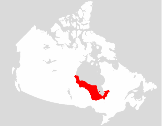
This is a map showing the Hudson Bay Lowlands.

This is a map showing the latitude and longtitude
Climate
The temperature of this region are sub arctic climates. It is very cold during the winter and summers are shorter. There is a lot of rain as this is a wetland area.
Churchill, Manitoba temperatures range from -30 to 17 degrees. Monthly precipitation ranges from 12 to 60 mm of rain each month
Moosonee temperatures range from -27 to +22 degrees. Monthly precipitation ranges from 25 to 100 mm of rain each month.
Attawapiska's temperatures range from -25 to +22 degrees. Monthly precipitation ranges from 25 to 75 mm of rain each month.

Churchill Climate Graph

This is Moosonee's climate graph

This is Attawapiskat's climate graph.
Soil Profile.
The Hudson Bay Lowland is a plain that is 85 % muskeg or peat wetlands and marshes. Part of this area is also permafrost and is frozen. As you move further inland the areas eventually become a boreal forest and the soil is peat like and does not drain well and is wet a lot.,
Causal Climate Factors and Impact of Climate Change.
Climate change is having an impact on the Hudson Bay Lowlands because the area is rapidly warming each year. It has warmed by 3 degrees since 1990 and it is starting to loose ice. This warming is causing a change in the aquatic ecosystem. Some people call this region the "canary in the coal mine" a it is a sensitive ecosystem.
Flora and Fauna of the Region
The Flora of this region has peat, sedgec, cotton grass and mosses. As you move to more elevated areas, you get willows. The more you go inland there are thick boreal forest with white spruce, balsam fire, aspen and white birch. The Fauna of this region are caribou, snow geese, Canada geese, and lots of polar bears. All of the flora and fauna have adapted to the wet and cool region of the Hudson Bay Lowlands in their own different ways. Many plants do not produce seeds because it is so wet, and the plants spread their roots to grow. Animals have very short breeding seasons since it is warm for only a few months.
Human Geography
Settlement Patterns and Major Cities
This area is not very well established as it is very far north, and very wet. There are only a few dozen communities. When the Hudson Bay Company closed some of its trading posts, many of the villages were closed. Some of the current existing communities are Churchill, Fort Severn and Peawanuck.
Economy
Past In the past the economy of the region was quite interesting. First Nations people - the Cree - did fur trading and trapping many years ago.
Present
Some of the present industries in the Hudson Bay Lowland are diamond and mineral mining. Also there are many rivers that flow into Hudson Bay and hydroelectric dams are being build to help produce energy. Tourism is also very popular as polar bears live here.
Environmental Concern
Climate change is impacting the Hudson Bay Lowlands. It is sometimes known as the "canary in the coal mine" as it is a sensitive ecosystem. This area has warmed by 3 degrees since 1990 and it is starting to loose ice. This warming is causing a change in the aquatic ecosystem. Also many of the animals in the area like the polar bear and beluga whales have chemicals in them like DDT. This is because they are at the top of the food chain and have eaten animals that are contaminated.
Comparison to other Locations.
I am comparing a region in the Hudsons bay lowlands to Forbisher Bay Baffin Island. Both regions are very cold at -30 to 12 degrees. Precipitation is 18 mm to 60 mm each month. Both areas have very little settlement and the winters are very cold.
The economic activities in Forbisher Bay Baffin Island are mostly mining, and tourism. Mining for iron, diamonds and other valuable resources.

References
https://www.google.ca/search?q=hudson+bay+lowlands+map+with+longitude+and+latitude&espv=2&biw=1360&bih=606&source=lnms&tbm=isch&sa=X&ved=0ahUKEwi2koiQ85PNAhULwWMKHfGTAq4Q_AUIBigB#tbm=isch&q=hudson+bay+lowlands+map&imgrc=fYNCQImoO9qMsM%3A
https://www.google.ca/search?q=hudson+bay+lowlands+map+with+longitude+and+latitude&espv=2&biw=1360&bih=606&source=lnms&tbm=isch&sa=X&ved=0ahUKEwi2koiQ85PNAhULwWMKHfGTAq4Q_AUIBigB#imgrc=ubhYCwSfgmFmTM%3A
https://en.wikipedia.org/wiki/Hudson_Bay_Lowlands
https://www.meteoblue.com/en/weather/forecast/modelclimate/attawapiskat_canada_5888118
https://www.google.ca/search?q=Moosonee+climate+graph&biw=1360&bih=606&source=lnms&tbm=isch&sa=X&ved=0ahUKEwjpxci795PNAhVJ5mMKHTlwCGAQ_AUIBigB#imgrc=0zWZnKKDTbmkkM%3A
https://www.google.ca/search?q=Moose+Factory+climate+graph&biw=1360&bih=652&source=lnms&tbm=isch&sa=X&ved=0ahUKEwjf-cf39pPNAhUNyWMKHbrFBj8Q_AUIBigB#imgrc=U9Ez9c8BmJU2sM%3A
https://en.wikipedia.org/wiki/Hudson_Bay_Lowlands
http://www.pc.gc.ca/eng/docs/v-g/nation/sec4.aspx
http://www.mapsofworld.com/lat_long/maps/canada-lat-long.jpg
http://news.nationalgeographic.com/news/2013/10/131008-arctic-warming-hudson-bay-climate-change-ice-paleoclimate/
https://en.wikipedia.org/wiki/Hudson_Plains_Ecoregion
http://cs.mcgill.ca/~rwest/wikispeedia/wpcd/wp/h/Hudson_Bay.htm
